Swift Engineering announced its Japanese Subsidiary, Swift Xi, signed an agreement with Japan’s New Energy and Industrial Technology Development Organization (NEDO) in a project called “Digital Infrastructure Development Project for Digital Transformation of Industries: Research and development on 3D spatial information infrastructures.” Both Swift Tactical Systems and Swift Engineering will support the project.
“As the Swift family, we are excited to be a part of this predominant and innovative project conducted by NEDO. And we would like to be the very first team in the world to establish a safe 3d Spatial Information Infrastructure System,” says Hiro Matsushita, Group Chairman/CEO at Swift Group.
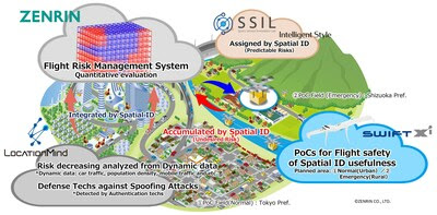
Swift Tactical Systems and the Swift group are collaborating with Zenrin Co. Ltd., LocationMind Inc., Intelligent Style, and Space Service Innovation Lab (SSIL) to develop a 3D spatial information infrastructure using the spatial ID. There needs to be a platform for understanding and identifying flight safety information.
NEDO’s Basic plan for this project is to use the spatial ID as a standard index, making it easier and more efficient to search, integrate, and utilize a wide variety of spatial information and provide spatial information in a machine-readable format. By providing this service, we aim to realize the safe and efficient operation of autonomous mobile robots such as drones, automatic delivery robots, and self-driving cars and create new value using spatial ID. Furthermore, by 2030, the Japanese government wants unmanned aerial vehicles (UAVs) and urban air mobility (UAMs) to fly in urban areas within Japan.
“Data integration of autonomous mobility, including drones, which will connect the digital and virtual worlds, is essential in creating the next generation of services. We have high expectations for this project, as it will be a milestone in this direction,” says Hiroshi Senzoku, Managing director at SSIL.
Each company collaborating on this endeavor brings a unique skill set to develop 3D spatial information infrastructure:
- SSIL will design specifications and build the 3d spatial information infrastructure.
- Intelligent Style will create the database architecture and prototype the system infrastructure.
- LocationMind will provide the dynamic data (people-flow analyses) to decrease flight risks in Zenrin’s system and test the usefulness of its spoofing protection system.
- Zenrin will develop a “flight risk management system” prototype, which will automatically make flight plans using its algorithms to maintain flight safety.
- Swift Tactical Systems, alongside the rest of the Swift Group, will advise, fly and make flight routes of UAVs under the guidelines of the “flight risk management system” developed by Zenrin to improve safe operations of UAVs under the 3D spatial information infrastructure. Swift will use its transitional Vertical Take Off and Landing UAV and other platforms to support flight operations.
“This project, with its goal of creating a 3D spatial information infrastructure, will establish safe flight paths for UAVs and UAM corridors in urban areas. We are proud to be a part of this project, driving the development of new infrastructure that will enable the safe and efficient operation of autonomous unmanned aerial vehicles and create new value using spatial ID. By leveraging the capabilities of our partners, we are confident in our ability to create a platform that will revolutionize how we fly in urban environments,” says Alex Echeverria, President of Swift Tactical Systems.


