Haritaevi Aviation Engineering Inc. Co. is now offering Obstacleanalyze, an Obstruction Evaluation Software that has been serving under ICAO standards since 2016 and is now available under FAA standards throughout the United States.
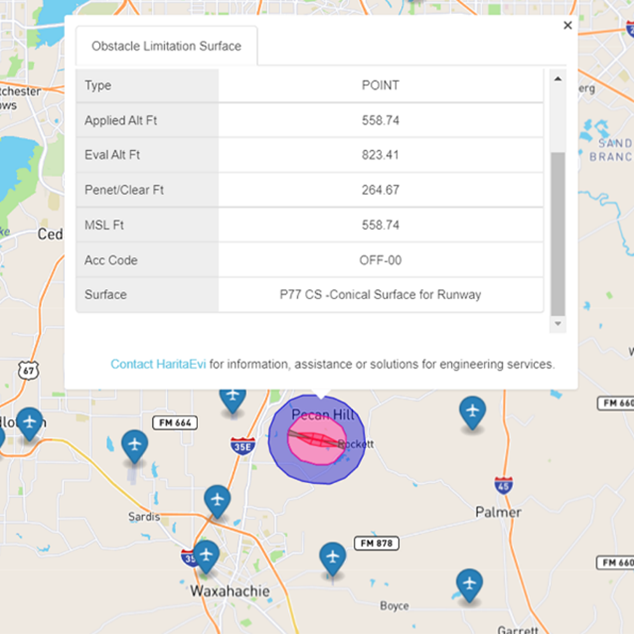
Obstacleanalyze is an easy-to-use Obstruction Evaluation Software Solution. It allows users to analyze 14 CFR Part 77 surfaces. Users can do a quick 24/7 check to see if you need to report your construction around an airport to the government. Moreover, it allows you to view Obstacle Limitation Surfaces (OLS) and the Permissible Height of Buildings around airports, either by querying the map or by querying the point. You can also add your own obstructions in Obstacleanalyze and query your results according to FAA standards. You can generate reports from your queries and export them in different formats such as XLS, CSV, PDF, and KML. If you wish, you can save your results and view them again later. Considering all these features, it can be said that Obstacleanalyze is the easiest way to access obstacle information for landowners, contractors, and investors.
What exactly does Obstacleanalyze do? By analyzing 14 CFR Part 77 surfaces with Obstacleanalyze, you can get the most accurate valuation of your property by learning its location in Airport Height Restriction Plans. It is also possible to learn whether the additions to the existing buildings comply with 14 CFR Part 77 or not. For example, you can find out if the solar panels meet the criteria and/or if you can lift your crane, and/or if the wind turbine you want to build complies with the standards. This information not only makes your job easier but also prevents you from incurring serious financial losses. Because those who penetrate the reporting requirements of Part 77 are liable to pay $1,000 for each day the penetration occurs. Also, Obstacleanalyze helps you see if the cumulative impact of the proposed construction or change, combined with the impacts of other existing or prospective buildings, could pose a threat to air navigation. For this reason, we can say that Obstacleanalyze has a key role in ensuring Aviation Safety in the USA.
As a result, Obstacleanalyze, located in the area where Geographic Information Systems (GIS) intersect with Aviation Safety, is an Obstruction Evaluation Software that provides aviation information to FAA standards. Thanks to Obtsacleanalyze, users can query a building’s compliance with Obstruction Evaluation Standards. Access to obstruction information is vital for those wishing to develop plans, projects, or start a construction on real estate surrounding airports. Constructions in accordance with the Obstacle Limitation Surface (OLS) are very valuable for every stakeholder. By providing this information, it aims to respond to the needs of people such as landowners, contractors, and investors. Obstacleanalyze, which has Technological Product Experience and Trademark Registration Certificates, provides an added value to the sector for safe urban development and safe flights.