
Colorado developed system is the first new radar system in nearly 40 years!
The Colorado Department of Transportation’s (CDOT) Division of Aeronautics, along with its partner the Federal Aviation Administration (FAA) took a bold step in 2009 when it launched a new system to provide radar-like surveillance to mountain airports 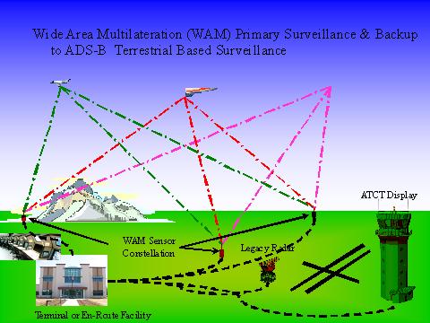 supporting Colorado’s high country tourism and general air safety in the state. The Colorado Surveillance Project, more formally known as the Colorado Air Traffic Control Beacon Interrogator (CO-ATCBI) Automatic Dependent Surveillance-Broadcast (ADS-B) System, successfully passed its critical one year test period and has been commissioned by the Federal Aviation Administration (FAA) into the National Air Space (NAS) System. This is the first new surveillance (radar) system in the NAS in nearly 40 years.
FAA assumed ownership of the system on September 12, 2009 including responsibility for the operational and maintenance cost of the system for its useful life, expected to be 15 years.
The Colorado Surveillance Project is truly a Colorado project. In addition to the funding provided by the CDOT Division of Aeronautics, the local communities contributed funds to the cost of the project and the State Telecommunications Group (OIT) made the States telecommunication system available to co-locate the units at various sites at no cost.
The $4.7 million Phase I system, which began operations on September 12, 2009, is now providing coverage to airports in Hayden, Rifle, Steamboat Springs and Craig through a new technology called Wide Area Multilateration (WAM). WAM provides surveillance through a network of small sensors deployed in remote areas. The sensors send out signals that are received and sent back by aircraft transponders. System computers immediately analyze those signals and are able to determine the precise location of an aircraft. The data is transmitted to screens viewed by air traffic controllers via the FAA Denver Air Route Traffic Control Center, located in Longmont, which provides radar separation for all air traffic in portions of nine western states. WAM has been critical in helping these airports solve a growing problem. The program costs for the development and installation of Phase I of the Colorado Surveillance Project was shared by the local airports, CDOT and the FAA.
“The Colorado Department of Transportation and the Division of Aeronautics are extremely proud of the working relationship we have with the FAA and the four airports involved in phase I of the Colorado Surveillance Project," said David Gordon, Director for the Colorado Division of Aeronautics. "This is a critical first step in demonstrating the viability of our country’s plan to replace old technology with new," said Gordon. "We are proud of our partnership with the FAA in assisting them with a critical and important initial phase of the Next  Generation Air Transportation System (NextGen).” (Gordon pictured at right. Photo by Shahn Sederberg)
During each winter season, high country airports experience a dramatic increase in activity when visitors to Colorado travel via commercial and general aviation aircraft to many mountain communities. Peak travel periods such as Thanksgiving, Christmas and New Year’s produce an even greater amount of ski travel, creating a “traffic jam” in the skies over Colorado. This situation becomes increasingly difficult during periods of inclement weather. Such an increase in air traffic, especially during high country snow storms can result in diversions, delays and denied service for aircraft en route to mountain airports that lack radar coverage. When an aircraft is diverted to an alternate airport such as Denver International Airport, passengers are then faced with having to rent vehicles to drive to their destination ski resort, thus diminishing visitor experience and placing additional pressure on Colorado highways. An equally important consideration was the increased air and ground travel due to the rise of the energy industry in western Colorado. For vacationers time is critical, often with a lodging reservation at stake. For a business person, time is money so a diverted flight could mean a missed critical business meeting.
In 2005, CDOT’s Division of Aeronautics began looking for ways to address this problem. The cost of utilizing existing, so called traditional or “legacy” radars to provide the necessary coverage in the mountains is limited by line of sight and was prohibitively expensive, as a single “legacy” radar costs in excess of $7 million, not including operation and maintenance. Another key element of the WAM system is that it utilizes existing aircraft equipment and does not require an aircraft to install special equipment. Working with the FAA, CDOT developed a solution based on a combination of existing and next-generation technologies to provide the desired radar coverage without the need for costly legacy radars. This is how WAM was developed.
The next phase of the Colorado Surveillance Project (Phase II) has already begun and is expected to provide airport coverage in Montrose, Telluride, Gunnison and Durango and is estimated to cost approximately $27 million.
“The importance of the commissioning for Phase I of the Colorado Surveillance Project cannot be overstated.,” said Harold Patton, Chairman of the Colorado Aeronautical Board. “The benefits derived from this project will enhance safety for the flying public and greatly improve the economic benefits to these communities. This project also exemplifies the accomplishments that can be achieved from cooperative efforts between government and private partnerships. The Colorado Division of Aeronautics and CDOT are proud to have been a part of this ground-breaking project and express our appreciation to the FAA for their support.”


