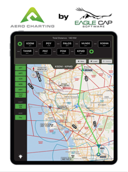
Eagle Cap Software has introduced its solution for the hobbyist flier, the pilot who enjoys the hundred-dollar hamburger but doesn’t like getting too techie. Aero Charting works on an iPad® and provides a moving map with vector aeronautical charts. It also allows custom route creation and integration with AOPA’s Internet Flight Planner.
Brian Leutschaft, Product Manager for Aero Charting at Eagle Cap, says, “We felt there was the need for a simple, easy-to-use situational awareness tool for pilots. It provides the basics needed to plan, navigate and fly the whole of US airspace. We put everything on one screen, made it work on the iPad, and made it free. How’s that?”
How is it free? Aero Charting is ad-supported, and for a limited time, users can permanently turn off the ads for just $9.99. Oh – and tell us what you think while your ideas are fresh in your mind. Just press the ‘lightbulb’ in the app to send us an email.
What’s next? Leutschaft says, “FAA’s IFR High, Low Enroute and Area charts along with VFR sectional charts. Stay tuned.”