Fortem Technologies announced earlier this month, a strategic partnership with Southern States LLC, a century-old leader in high-voltage switching and grid-resiliency technology. Together, the companies are equipping utilities with advanced, scalable solutions to detect, track, and respond to drone-related threats targeting critical grid infrastructure. Southern States recently launched its Airspace Awareness product line, integrating Fortem’s […]
Unmanned Systems
Unmanned Systems


Dedrone by Axon Releases 10th Annual Airspace Security Report
Dedrone by Axon released its 10th annual report, which charts how drone behavior, CUAS adoption, and airspace risk have shifted across public safety, enterprise, and defense. It also highlights what they expect to see in 2026 as it relates to airspace security. (Report Follows) As the global leader in airspace security, Dedrone by Axon is […]
Oregon Department of Aviation and Lane Community College Partner to Advance Drone Technology for Wildfire Mitigation and Workforce Development
The Oregon Department of Aviation (ODAV) and Lane Community College (LCC) have entered into a Memorandum of Understanding (MOU) to collaborate on the use of uncrewed aircraft systems (UAS) and advanced sensors for wildfire mitigation research and workforce development. The partnership establishes a cooperative framework to explore drone-based technologies, including Beyond Visual Line of Sight […]
Commercial Drone Alliance Welcomes Xelevate to Its Board of Directors
The Commercial Drone Alliance (CDA) has announced that Marcy Eisenberg, President and Co-Founder of Xelevate, has joined its Board of Directors. The CDA’s Board acts on behalf of the entire membership, helping to shape the organization’s strategic direction. Eisenberg has deep expertise in economic development and brings hands-on drone infrastructure expertise from building one of […]
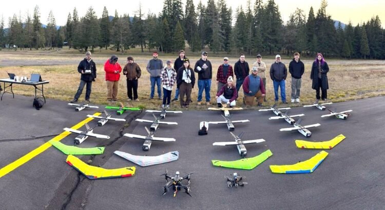
Osage LLC Hosts Osage Nation Congress for Tour and Presentation of Future Skyway Range Plans
Osage LLC welcomed members of the Osage Nation Congress for an in-depth tour and lunch briefing at Skyway Range, offering a first look at an ambitious vision to transform the area into a leading center for uncrewed aerial systems (UAS) innovation, testing, and economic growth. The visit provided Osage leaders with a comprehensive overview of […]
Virginia Launches Advanced Air Mobility and Unmanned Systems Test Site Program
The Virginia Innovation Partnership Corporation (VIPC) and the Virginia Department of Aviation (DOAV) have announced the launch of the Commonwealth of Virginia’s Advanced Air Mobility Test Site Program, a new pilot initiative to evaluate and integrate next-generation aviation technologies across Virginia’s transportation and innovation ecosystem. Developed to support the deployment of unmanned aircraft systems (UAS), […]
Drones Transport Medical Supplies to Healthcare Station in Helsinki
Helsinki is currently exploring how drones could assist with transport during exceptional circumstances. The flights in November will cover a distance of around seven kilometers and will be flown several times per weekday. In early November, the City of Helsinki is piloting drone transports for healthcare supplies on an approximately seven-kilometer route from Kyläsaari to […]
Oklahoma High Schoolers Compete in First Annual Drone Search and Rescue Championship
Thirty Oklahoma high school teams showcased their drone-powered search and rescue skills at the inaugural “Fly Forward: Search and Rescue State Championship” on Tuesday, Oct. 21 at Lake Carl Blackwell in Stillwater. The day-long event was hosted by the Oklahoma Department of Aerospace and Aeronautics (ODAA) and the Oklahoma Aerospace Institute for Research and Education […]
ZenaTech Selects Baton Rouge as Base for Advanced AI-Driven Drone Solutions for US Defense and Homeland Security
ZenaTech, Inc. has announced that it has selected Baton Rouge, Louisiana as the base for Zena AI, Inc., the company’s specialized AI division that will develop next-generation drone technologies for US defense and homeland security applications. The company has signed a lease for a secure office space in the Downtown Baton Rouge area and will […]
EagleNXT Debuts MicaSense RedEdge-P Triple: A Game-Changer for Precision Drone Imaging
AgEagle Aerial Systems Inc. has announced the launch of the company’s MicaSense™ RedEdge-P™ Triple sensor package. This groundbreaking system, featuring each of the company’s three RedEdge-P camera models mounted simultaneously on a single drone, establishes a new standard for capability in precision agriculture, environmental monitoring, and geospatial mapping. The RedEdge-P Triple captures 15 spectral bands […]
